


Canyon Dades

katiab
User

Length
7.3 km

Max alt
1710 m

Uphill gradient
167 m
Km-Effort
9.5 km

Min alt
1607 m

Downhill gradient
166 m
Boucle
Yes
Creation date :
2022-10-07 09:26:34.933
Updated on :
2022-10-10 09:17:57.588
2h36
Difficulty : Easy

FREE GPS app for hiking
 SityTrail
IGN / Geographical institutes
SityTrail Plus
The world is yours!
About
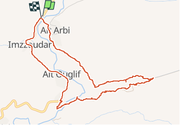
Trail Walking of 7.3 km to be discovered at Drâa-Tafilalet, cercle de Boulmane-Dadès, Ait Sedrate Jbel El Soufla. This trail is proposed by katiab.
Positioning
Country:
Morocco
Region :
Drâa-Tafilalet
Department/Province :
cercle de Boulmane-Dadès
Municipality :
Ait Sedrate Jbel El Soufla
Location:
Unknown
Start:(Dec)
Start:(UTM)
217461 ; 3484613 (30R) N.
Comments